Approval Process
Submission to Wet Tropics Management Plan Zoning Amendments
Submission to Wet Tropics Management Plan Zoning Amendments
To: Zoning Map Amendments
Wet Tropics Management Authority
PO Box 2050
Cairns QLD 4870
margaret.woodland@epa.qld.gov.au
Index
1) Summary
2) History
3) Perceived need
4) Selecting one option
5) Biased assessment reports and negative impacts
6) Changed circumstances
7) Prudent and feasable alternatives
8) Closing
Appendices
a) Vereina tunnel clarification (PDF)
b) Drainage and Water Quality (PDF)
c) Scenic Route (PDF)
d) Southern Rail tunnel (PDF)
e) Supplementary Study - assumptions (PDF)
1) Summary
You are asked to recommend on and make a decision which will affect not just the health of the WTWHA (Wet Tropics World Heritage Area) you are charged to protect, but also will significantly affect the wider community, the tourism industry, environmental values of the Cairns and Northern Tableland areas and Australia’s international standing.
I warn the Wet Tropics Management Authority and the Ministerial Council to base their recommendations and decisions about the rezoning of WHWTA on the unobjective, highly biased, deceptive and at times even deliberately untrue information provided by the Department of Main Roads for the proposed "upgrade" of the Kuranda range to a 4-lane highway. To allow rezoning without a truly independent review of the DMR reports and available alternatives is like letting the wolf take your sheep for grazing...
In this submission I will prove the above charges and demonstrate that DMR's claims of "no net adverse impact" are unrealistic and mere wishful thinking. Furthermore I will present prudent and feasible alternatives which DMR has never considered and has been unwilling to even discuss with the author.
It would be a shame if the largest ever public capital investment in our region would be made without looking at the larger picture of better development patterns, better transport and energy options as well as long term issues like global warming. The latter means it is even more important to protect fauna and flora from any additional stresses.
Furthermore there is no point accepting any negative impact on WHA now if the 4-lane highway would be obsolete before it is finished because of skyrocketing petrol prices due to peak oil.
Last but not least there are prudent and feasible alternatives and development in the Mareeba area is not just much better for WHA and the Kuranda tourist industry but it is also more feasible and possibly more welcome by residents.
DMR has clearly failed in its obligation to give an objective assessment of the "Upgrade" project.The proposal as presented cannot be truthfully judged as having "no net adverse impact" and there is at least one prudent and feasible alternative.
Therefore the rezoning application cannot be approved in accordance with current World Heritage legislation and strategy.
2) History
2.1) Traffic Conditions on the Range Road
I have been living for over 20 years in the Kuranda area. I can remember the construction of only one new overtaking lane on the range road in that time and that is on the way down just below Avondale creek. That must be the most useless overtaking lane in the whole country and is used by hardly any slow vehicles.
All other widening work on the range road was to allow bigger and heavier trucks which have a decidedly negative impact on other users. DMR has gone even further. Not only did they fail to provide any effective overtaking opportunities despite increasing traffic and more slow trucks, they have actually removed three overtaking opportunities altogether and shortened many others. It is obvious that all of these actions (and non-actions) have led to what is now an increasingly negative experience for drivers. This could be seen as a deliberate strategy by DMR to influence public opinion (similar to Sydney traffic lights staying red longer to encourage people to use the toll road) and should be investigated.
Cairns City Council is adding to the problem by insisting to transport their rubbish by trucks to Springmount (which was selected for its proximity to rail) despite Bedminster being operational. These trucks stink and their leakage might have contributed to accidents according to anecdotal reports.
2.2) The Planning Process
The piece meal approach to the approvals for this 4-lane highway seems to be deliberately designed to avoid looking at the whole picture and to get the result DMR wants.
First Kuranda/Koah get identified as growth areas probably because they are the first areas on the Tablelands along the existing road from Cairns.
Why was Mareeba not considered at that time? Was a tunnel to Mareeba even contemplated?
Next different transport options are looked at, but again without lateral thinking and in a way that inevitable leads to the selection of the 4-lane
highway option
Next evaluations and assessments of that option are done, but they are commissioned by the proposer and the resulting reports are inevitably biased
and are written to bring the proposal forward rather than to have an objective look at it.
By the time the public is asked to comment on the selected project there are more pages of reports than anyone can read through and the process discourages
any past decisions being reconsidered in the light of new evidence or new alternatives being considered (even if they never were looked at eg rail
tunnel and Mareeba development). Changed circumstances (see 6) are also ignored by this approach.
I also note that putting public consultation periods over the Christmas period and keeping them short ensures reduced opposition.
This latest submission period has been started and even finished long before all of the related material was available.
Such a biased and slanted process for what is the largest ever capital expenditure in North Queensland is totally unacceptable.
I ask WTMA to take a holistic view of all associated issues when making their decision.
3) Perceived need
3.1) 2010 Plan
One of the main arguments for the proposed 4-lane highway is the perceived need to develop Kuranda as a Cairns suburb. The 2010 plan calls for 50,000 -90,000 people in the Kuranda area. This would undoubtedly be a bonanza for real estate developers, but it is highly debatable whether it would benefit the wider community and whether there really is a need for such massive development and it now looks as if the projections used in 2010 were highly exaggerated.
The lowest estimate of the 2010 plan for the Cairns population in 2006 is 138,910 (high estimate is 146,000) while Mareeba is estimated to have
at least 20400.
Average growth for Cairns from 1999 to 2004 has been 1.5% with a population of 125,132 on 30th June 2004; Mareeba is reported to have an average
growth rate of 0.3% and a population of 18,659 on 30th June 2004 (both www.ausstats.abs.gov.au).
For Mareeba the actual 2006 population will not even match the lowest forecast of the 2010 plan for its 2001 population!
Increasing the actual 2004 Cairns population by the experienced average of 1.5% would mean a population of 128,914 on 30th June 2006. Using the exceptionally
high 2.3% increase in 2003/04, that figure would be 130,954.
In either case the real figure will be significantly lower than the lowest estimate in the 2010 plan, indicating the need to reassess that plan.
Its perceived need for large suburban development is vastly exaggerated.
3.2) Choice of Areas to be Developed
But even if there is a need for additional development areas, to have such massive development in one of Australia’s most sensitive environments right next to World Heritage areas is utterly irresponsible and I ask WTMA not to allow it to happen (and your permission for rezoning would make it inevitable).
I note that the 2010 plan simply states that "development of one or more urban nodes ... between Kuranda and Mareeba" is the "preferred development strategy". However I cannot find any reasoning why it should occur there except a reference to a "reasonable commuting time to employment in Cairns"
The plan also calls to "encourage and facilitate economic and urban development opportunities for the Mareeba and Atherton areas".
However the plan also notes that "Kuranda's focus as a tourism centre may not be compatible with more intensive developments" and "In
addition, the dispersed nature of the surrounding rural residential development does not allow urban services to be provided in an efficient manner."
It appears that the 2010 plan started with the premise that Kuranda was already selected for development and then continues to establish the case for such development.
It is regrettable that the 2010 plan never looked for less environmentally sensitive areas for any development. The obvious choice is Mareeba which
already has a lot of the required infrastructure. And through a tunnel commuting to Cairns is the same or shorter than commuting from Myola or Koah.
Additionally most people in Mareeba may welcome large scale development while most people in Kuranda do not.
3.3) Proponents of Range Upgrade and Kuranda development
Please be aware that there are two main interest groups who push for this project and would benefit from the proposed 4-lane highway: trucking companies and real estate developers. The former can sack half their workforce by employing B-doubles and B-triples (causing lost jobs and inconvenience to other users). The latter stand to make huge profits by cutting up and selling off some of Australia's most sensitive country (causing a decline in tourism, a rise in social problems and natural degradation. Please note that the profits of both of these interest groups come at the expense of the general community.
Even if a road or rail tunnel to Mareeba would be three times as expensive as the proposed option, the value of preserving world heritage and Kuranda's tourism surely would make more than up for it and it is more in the long term interest of the wider community than this 4-lane highway.
I ask the WTMA to request a review of the 2010 plan in the interest of the wider community and WHA.
4) Selecting one option
4.1) Decision Based on Wrong Costing
In the 2000 transport study all other options were ruled out mainly based on highly biased costing.
At that time the present 4-lane option (C1) was priced at 249 million dollars while for example the T4 rail option (19km of tunnel) was priced at
1117.4 million dollars. None of the rail options at that time considered drive on/off carriages so cars and trucks could use the rail. In short
the alternative options chosen were designed to not be real alternatives.
It should be questioned whether this was just a lack of lateral thinking or deliberate, just like it is questionable whether the totally biased and
wrong costing were just a lack of ability or a deliberate deception of decision makers at that time. Seeing the incredible bias of DMR publications
(see below) I do have my doubts....
Anyway that decision was taken when the train option was believed to be about 4.5 times the road option and the decision makers were in the belief that rail could not remove trucks from the range road and B-doubles could still not get down the range with the train option.
4.2) Updated and Real Costing
By June/July 2004 the costs for the 4-lane highway ballooned to just within 500 million dollars (verbal information by Paul Jones) which probably does not yet account for any visual amelioration and replanting costs. Since then DMR has refused to provide any cost updates.
On the other hand I received information from Rhätische Bahn in Switzerland that they constructed a rail system with a 19km tunnel including
a 2km double track section for passing, a second 2.1km tunnel, including rail, fittings and rolling stock for under 750 million AUS$ at today’s
money - required tunnel length here would be shorter but above ground rail longer, but overall this should provide a good ballpark figure (email
'Vereina_tunnel_clarification' attached).
This seems to indicate that the 1999 costing by DMR of a rail option was excessively high while the costing for the 4-lane highway was extremely
low.
To further slant the figures DMR does not account for the inevitable costs of 4-lane upgrades from Kuranda to Myola and to Koah and for 6-8 lane upgrades from Smithfield to Cairns and through Cairns to southern highway (or a Cairns bypass). The Smithfield through Cairns to southern highway roads are already at the limit of their capacity. The Smithfield/Cairns upgrade would require very expensive fly-overs and on/off ramps at every roundabout and intersection. Adding all these follow-on costs would bring the total costs of the proposed 4-lane range option very close if not even above a rail tunnel option. And as the Swiss experience shows rail can easily shift trucks and B-doubles down the range - making for a very different situation now.
Please note that the decision to go for the present 4-lane option was taken because of these highly biased and inaccurate figures, which by now
have proved to be totally inaccurate.
A decision made on such totally wrong costing and assumptions needs to be re-assessed.
If you are looking at buying a car and one car is 4-5 times more expensive than the other, you would probably decide on the cheaper one, especially if you are told that the expensive one cannot do everything you need. But you will surely reassess the situation if you hear that the actual price is nearly the same because the initial costing for the cheaper one did not include the wheels or the motor or the paint etc, especially if the other car is cheaper to run and has numerous extra benefits and can do more than what you need!
4.3) Incremental Benefits
Another reason for an "upgrade" over a rail option was given as the perceived "incremental benefits". This is misleading and
highly disputable for the following reasons:
i) a tunnel option would have avoided the lengthy approval process because it probably would not require rezoning of world heritage or at least a
much simpler assessment
ii) similar tunnels overseas have been planned and built in ~10 years
iii) the "upgrade" would for the first few years lead to significant impacts on road users. Transport of bridge parts and blasting would
probably require frequent and total road closures for significant periods of time; there would be extended time periods of weeks or even months with
only one lane traffic; there would be additional delays for other reasons.
So in the first 5-10 years of construction there would be no "incremental benefit" at all but rather a severe inconvenience and significant
loss of time for all road users
iv) even after half of the new road is built, the above delays on the sections under construction are likely to more than negate any benefits of
the finished sections. What is the "incremental benefit" of ten kilometres of new 4-lane highway if then you have to wait several minutes
or even hours at the construction site?
In summary negative impacts of the construction are likely to negate any incremental benefits until the whole project is finished in 10-20 years. Until then it would be a liability.
In fact a tunnel option including planning and construction will still be completed before the 4-lane highway would. And providing some additional overtaking opportunities in the next few years will create enough incremental benefits until the tunnel is operational.
4.4) Considering Future Plans
DMR in its 2000 transport study calls for the construction of a 4-6 lane highway on a completely new alignment through virgin WTWHA from Koah to Kamerunga as soon as this 4-lane highway is built:
I ask WTMA to consider these future plans when making your decision and then consider that a second rail tunnel at that time - see 7a) and 7b) - would be cheaper and much better for WTWHA. Please be aware that should you approve the present rezoning application DMR intends to ask you to approve another rezoning for the Koah/Kamerunga road corridor.
5) Biased assessment reports and negative impacts
5.1) General
All of the DMR commissioned reports I have read, which is about half to two thirds, appear to have been written to prove the case for the proposed project. I am very concerned at the total lack of objectivity in those reports.
In my understanding these reports were supposed to give independent and objective assessments of the various aspects of the proposed 4-lane highway, which they clearly fail to do.
As shown below I found these reports to be highly biased, knowingly deceptive and at times factually wrong. Substantial and known negative issues have been totally ignored, glossed over or hidden in a small sentence amid hundreds of pages. Comparisons used are always chosen to favour the project even if the comparison has clear and obvious shortcomings or is totally inappropriate and a more realistic comparison is available. Images were carefully chosen to present the project in good light.
WTMA's own rezoning criteria requires "no net adverse impact on the integrity of the area". DMR's wrong assumptions eg that views from the road would be improved and that the route would be more scenic are key arguments in such assessment of "no net adverse impact". There are about 4 pages of assumptions (please see attached document 'Supplementary Study - assumptions') without all of which there will be "no net adverse impact". As shown below some of the critical issues will definitely have negative impacts and DMR's arguments are severely floored and their assessments deceptively biased. I ask the board to not base their decision on DMR's "evidence".
Please also note that the below points are only a few of the many I have noticed and I have not even read all of the IAS and its addendums.
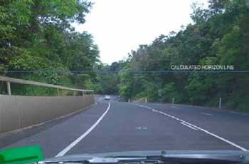
5.2) Scenic Route
The executive summary of the ‘05 addition to IAS 7.7.2 Findings states:
"The proposed upgrade represents the creation of a scenic drive experience, in contrast with the existing drive experience that is largely perceived
as simply a route between destinations."
As a response to public concerns, this statement is deliberately untrue, highly biased and deceptive. Not only does it ignore the fact that the present
road is overwhelmingly seen as a scenic drive but it also ignores the effect on views of the horrible concrete barriers of the proposed road which
would be creating an open tunnel experience with very limited views for most users. Or does the author really consider views of mainly concrete,
road, batters and sky as more scenic than glimpses of coast through rainforest?
A search on Google for "Kuranda Range Road" has found nine of the top ten results (DMR and FoE-Kuranda websites not included) describing the existing Kuranda range road as "scenic" (please see attached 'Scenic Route' document).
For the executive summary of the 2005 addendum to propagate such an obvious untruth, after DMR received detailed public submission materials proving the opposite, is an indication of the lack of objectivity and the intent to deceive the public and decision makers on the negative effects of this project.
5.3) Visuals
5.3.1) Views of the Project
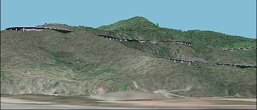
DMR has spent a lot of money to counter numerous claims by the public that the project would look terrible. It is notable here that DMR's efforts concentrate on replanting and rely on digital imagery to create the illusion of a highway blending into the surrounding country side. It is also notable that those efforts concentrate on small selected aspects of the project. DMR claims that the below image does not take into account the replanting and amelioration work.
Firstly what DMR does not show in below image nor talk about is the significant shadows the bridges would throw as the day advances nor the moving cars and trucks with sun reflecting off them. While any replanting (if successful - see 5.8) would have only a minimal impact for the shown perspective, shadows, moving vehicles and sun gleam would make it significantly worse. Again for many pages on end DMR focuses on one possibly positive aspect while deliberately ignoring to discuss the definite negatives - where is the objectivity?
DMR also fails to discuss the view of the project during the 10-20 years of construction, refusing to deal with public objections pointing those
out. This deliberate bias goes as far as producing an image claiming to show the view 2 years after construction that conveniently assumes the whole
stretch from Smithfield to the top is constructed at the same time. Unsurprisingly the angle and huge distance that image was taken from are carefully
chosen to minimise any negative impact.
This is digital trickery and deceptive photography, not objective assessment. Why did they not use the same aspect as in the original image above?
With a football-field sized vertical wall in the back of Smithfield, cuttings which are over 10 stories high and up to hundreds of meters long and bridges up to 50 meters high and half a kilometre long, no digital trickery can restore the loss of Cairns' famous, uninterrupted, green hills.
Nor does DMR address the effect of headlights at night. Why have we not been supplied with an image simulating the areas of the range which would be constantly or intermittently illuminated at night?
The views of the project would definitely represent a 'significant adverse impact'.
5.3.2) Views from the proposed road
DMR prepared an eyelevel virtual drive simulating the drive experience of the proposed road. After what I believe to have been the only public showing
at envirofiesta 2004 that simulation was withdrawn and DMR has since refused to show it or supply copies. DMR reasoned that the simulation could
only be shown in attendance of an engineer due to its short comings (and there was none available).
I suspect that the real reason was the devastating effect this simulation had on myself and others who watched it (it made me a firm opponent of
the project).
I note that this constitutes a clear case of DMR hiding negative evidence.
I strongly urge WTMA to request a copy and view this eye-level simulation (not the fly-over) and remember that the eyelevel represents the view in a very high 4-WD - all other cars will see even more concrete and less scenery.
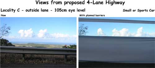
After I publicly compared the drive experience to an open roofed tunnel and submitted a detailed study to DMR about the lack of scenic views from
the road, DMR responded with several images in the latest addendum. As the related text explains "Three different photos were taken through
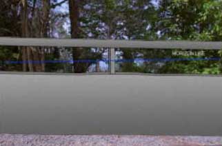
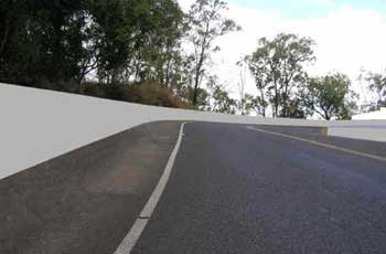
the front and side windows of a driving automobile, i.e. with eye height at approximately 1050mm above road surface level."
The below left image (7.6 UP5_Visualisation) shows 1100mm high barriers, yet from an eyelevel of 1050 you can see the top of it. This is impossible
and a significant deception of the public and decision makers.
Considering the importance of the views from the road, this wrong information requires a public correction showing what it would really look like
from a 1050mm eyelevel (which represents the worse case scenario).
Furthermore the choice of location depicts a background of green trees when in reality there would be hardly any trees left on the eastern side of
the road
The image on the right gives the correct impression and as you can clearly see it is ridiculous to judge such a view as "better" than
now as DMR does.
Please find attached images for higher cars. These images were taken just above the hairline bend which happens to be the best possible scenic view
from the top of the range down to Smithfield out of the side window of a car. Any higher in altitude and less ocean/coast can be seen; any further
down and you would not be on the outside anymore and you would not see any scenery - only the three other lanes and concrete barriers.
BTW this is another point the biased report fails to mention - that views from the road for at least the two hillside lanes is always very poor and
can in no way be described as "scenic".
DMR also supplied a photo montage out of the front window (also wrongly claimed 1050mm eyelevel).
To DMR's credit, the text actually mentions that "Although not illustrated in this report, for ascending traffic forward views will be significantly
obstructed by the barriers and will be directed towards the road ahead.
Occasional glimpses of the scenic landscape will create a degree of frustration, and will result in passengers attempting to look backwards or to
move about in car or bus(‘rubbernecking’), attempting to catch further views towards the surrounding landscape of high scenic value.",
the image shows only the going down perspective."
No reason is given why that perspective is not illustrated but the better case of going downhill is. I assume that it is because a picture speaks
a thousand words and DMR does not want to show the negative aspects.
It is important to note that those 'photo montages' are conveniently but unrealistically showing trees which would not be there and fail to show
all four lanes and inside barriers, especially when all they had to do is take an image of the eyelevel virtual drive. The location is selected to
have an s-bend to the left, an embankment on the left and an unusually strong decline, probably the very best location to minimise the effect of
the barriers.
These images are totally inappropriate, incorrect and can only be seen as deliberate deception. Please refer to the image below on the right to give
some indication of the view on the way uphill. Sorry, I have not had the time to include the truck rail or to remove at least most of the trees in
this image, which would make it much more realistic, but you can get the idea and see that there will be no "scenery" on the way up at
all ...
Last but not least DMR fails to mention that the lower 820m high barriers are only planned in front of embankments, so the images of those low barriers in situations where there is no embankments are inapplicable (eg image 7.3 and 7.5 page21 UP5). DMR knows this very well, but prefers to knowingly deceive the public and the decision makers.
It is totally unacceptable that DMR still insists that views from the road would be better than now and be judged a "positive impact" and
tries to defend that position with untrue information and deliberately deceptive imagery and reports while at the same time refusing to release the
eyelevel virtual drive.
I challenge their assessment and demand that views from the road be truthfully declared as much worse than now and weighted as a "significant
adverse impact".
5.3.3) Views from Skyrail
Again, despite the issue being raised in public submission there is no discussion at all in the UP5_visualisation of the views from skyrail during construction. Surely a 10-20 year effect is significant enough to be discussed?!?
What are international tourists going to say when they see trees being cut and bulldozed in WHA, what effect are their photos going to have on our areas standing as an eco-tourist destination?!?
Why are those expensive reports silent on such a long-lasting and important issue?
Even if (and that is a very big if) amelioration could be as successful as the report's images try to convey, the views from Skyrail would clearly be a "significant adverse impact"
5.4) Traffic delays
DMR is very quiet on this topic except saying that they are working on 'minimizing disruption'. The fact is that all of us road users are going to experience severe and prolonged traffic delays for the next 15-20 years if this project goes ahead. On top of the usual delays we have become accustomed to, delays would be for extended periods of no traffic at all eg for blasting and then removal of blasted materials or for transport of bridge parts (30 bridges in total). At other times we would be restricted to single lane traffic for weeks (or even months?) on end and all of this with traffic levels which will be increasing more and more.
How can DMR claim to give objective assessments of this project if they refuse to tell the public about such significant impacts on every single user for 10-20 years?!? Instead DMR talks about "incremental benefits"...
Traffic delays are definitely a "significant adverse impact"
5.5) Drainage
"Issue: Road Runoff Strategy
The only details not provided are the precise locations of the fine pollutant traps and their detailed sizing and design."
This insinuates that there are only minor design issues while in fact there is no practical way that even the 'first flush' could be treated since
the holding tanks would have to be of unacceptably large volumes.
Please also refer to the attached document 'drainage and water quality' which demonstrates that there is no feasible way to treat runoff to a satisfactory standard and that there is not even an intention to treat or minimise construction runoff.
Drainage and water quality needs to judged as an "adverse impact"
5.6) Leaves removed and concrete leaching
To dismiss concrete leaching and leaves caught on the road as "extremely minor effects" without any quantification to support such judgement is unacceptable bias (page 62 UP3_Analysis of Issues). Significant amounts of lime would undoubtedly be released into the environment year after year changing the pH accumulatively. Without quantifying the effect it cannot be dismissed as "extremely minor". Most gardeners can testify to this effect, and they typically use only a few scraps of concrete to increase the pH around their plants. So if their few scraps have a visible and measurable effect, leaching of 130,000 tonnes of concrete in WHA cannot be dismissed as an "extremely minor effect".
Leaves being caught by the concrete barriers is also not a minor effect. If we look at a strip of 50 meters on each side of the road that area would receive 20% less leaf cover than now (total width 125 meters, road 25 meters). This is a significant reduction in mulch and water retention. Consequently those areas (total area of 125 acres) would become dryer. This effect adds to the fact that areas under bridges will receive much less rainfall anyway.
But the worst effect of leaves staying on the road is for drivers in wet conditions. It is well known that leaves on wet surfaces are a serious problem and can significantly decrease tyre traction. In this tropical area extreme rainfall of 20mm in five minutes is a one in ten year event (and will be more extreme and frequent due to global warming). Such a downpour would likely pick up all leaves which would clog any grids and filters on the drains and then just wash down the road creating dangerous aquaplaning conditions.
For this report to dismiss this as an "extremely minor effect" is an unacceptable bias which could endanger lives.
These issues are at least "adverse impacts" and potentially "significant adverse impacts"
5.7) Noise effect on animals
Noise level measurements we took under both the Kuranda Barron river bridge and the Davies creek bridge showed that noise is between 70 (for single
cars) and up to 100 Db (for two or three big trucks). Noise reduces by only 10 Db for distances of 50-100 meters.
Preliminary assessment of animal tracks under the Davies Creek Bridge and in its vicinity showed that there was no animal tracks found in sand under
the bridge while there were tracks found in sand which was more than 100 meters away.
It seems evident that the high noise level would make it highly unlikely that the wildlife corridors under bridges would actually be used. We note that DMR reports refer to a totally different system of wild life underpasses. That system uses big drainage pipes with significant thickness of concrete between it and the road surface. A bridge has much higher noise levels than such a 'wildlife tunnel' would. This is yet another case where DMR reports uses incompatible examples to make biased but incorrect comparisons and implies success where there will not be any. When looking at the effectiveness of bridges as wildlife underpasses using wildlife tunnels it is a totally unacceptable comparison specially if there are bridges to look at (like Davies Creek Bridge).
Cassowaries in large areas would most likely be displaced/disturbed by the large amount of blasting required over 10-20 years due to their high
sensitivity to low frequency noise (October 2003 Auk, Andrew L. Mack of the Wildlife Conservation Society in Papua New Guinea and Josh Jones, now
of Scripps Institution of Oceanography in La Jolla, Calif. see http://www.sciencenews.org/articles/20040110/bob9.asp and http://news.nationalgeographic.com/news/2003/11/1104_031104_cassowary.html).
Blasting for such extended periods would likely have a very negative effect on cassowary habitat. Any effect of blasting and also of Heavy truck
vibrations/low frequency sounds on cassowaries needs to be researched before committing to this project.
With cassowaries being such a threatened and iconic species, it is deplorable that DMR simply ignores public submission material on this topic.
Page 36 UP3_Analysis of Issues c) Conclusions
"The effect of noise on a range of fauna under rainforest conditions is not well known although noise is one of the criteria leading to edge
effects (an impact identified in the IAS Addendum and considered in the Assessment of Net Adverse Impacts study) and identified in submission 16
(research has shown that arboreal mammals and birds move away from roads, thereby reducing habitat). Further work has been committed to investigate
the noise effects and possible mitigation strategies (see Section 3.14.2).
When expressing concern about the upgrade's noise effects on fauna, there is probably a tendency for the community to compare the existing road's
current traffic volumes and associated traffic noise with that of the proposed upgrade. The more appropriate comparison is between these impacts
from the existing road in 10-15 years' time and from the proposed upgrade. Increasing traffic volumes on the
existing road will also have implications for noise effects on fauna, regardless of whether the upgrade is carried out or not."
This conclusion on noise effect on fauna is unacceptably biased. Please note that in the preceding discussion the single 'positive comment' was given
20% of discussion space while the comment '528 Blasting noise from construction will affect cassowaries.' is not even discussed. Also the argument
that "Increasing traffic volumes on the existing road will also have implications for noise effects on fauna, regardless of whether the upgrade
is carried out or not." misses the point that the 'upgrade' would result in an eight times increase in traffic capacity than would be possible
on the existing road! And the typical "Further work has been committed to investigate the noise effects" is unacceptable. It asks you to
ignore data which suggests a highly negative impact and implies that negative effects would be mitigated by further research. If they are not it
is too bad...
The truth is that the huge increase in noise levels has the potential to totally negate any positive effect of the planned wildlife corridors, one of the main arguments for a "net environmental benefit".
Consequently noise effects on animals needs to be judged at least as "adverse impact", possibly even a "significant adverse impact".
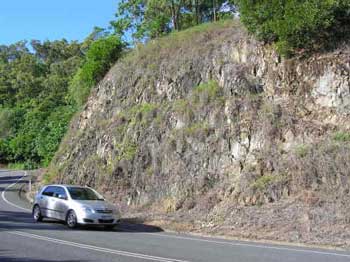
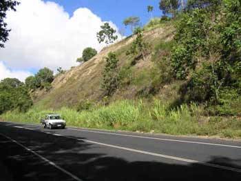
5.8) Replanting
The report (UP5_Visualisation) uses studies and images from the Palmerston Highway to demonstrate successful regrowth of batters and cuts and other
areas (which looks very impressive). At no point of the report is there any mention that the Palmerston receives a much higher rainfall and has much
better quality soil. In fact there are significant cuts on the range road (see image 'regrowth_1') and very close by on the road to Speewah (see
image 'regrowth_2'). The former is in rock as is going to be the case with most cuts on the proposed project. The latter shows about ten years of
natural regrowth on the typical poor soil of this area (with some patches of rock). These samples are much more realistic than the lush images from
the Palmerston.
It needs to be questioned whether the report omitted soil and rainfall differences and failed to discuss much closer cuts in order to deliberately
deceive the public and you as the decision makers. In the face of local samples being available there is no other reason to select unrepresentative
samples from a totally different area with much better soil and higher rainfall.
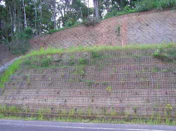
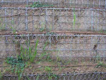
DMR has recently conducted a test planting of a stabilised embankment in Kuranda complete with irrigation system. An inspection of the project about
three month after establishment showed that nearly 1/3rd of the plants had died. As the below images illustrate the structure is basically taken
over by weeds (including a lot of sensitive weed). Please also note the washout lines in the top of the left image (Replanting_1) after only light
rains. As you can see in the picture on the right no care has been taken when cutting the mesh for planting (in front of the three indents in matting)
leaving sharp spikes which can potentially injure animals or growing plants (plants died already).
This test planting demonstrates the carelessness of DMR when it comes to plants and environmental issues as well as the unreliability of their proposed
mitigation strategies. It also clearly shows that successful plantings require years of intense maintenance - which has not been priced into the
total costs.
If DMR cannot even look properly after this show trial, what are the chances of success for their proposed replanting for the whole project?!?
Replanting is an attempt by DMR to mitigate clear and significant adverse impacts. While the DMR commissioned reports have an overly optimistic but unrealistic view (for above reasons) on replantings, the truth is that replantings are highly unlikely to mitigate the "significant adverse impacts" of clearings and visibility to an acceptable level. At best they might provide minimal improvement.
5.9) Geology
This report compares the present road with the proposed one and highlights the many planned devices and methods to minimise slips. It never explains why most of these have never been used in the past on known problem areas.
However the report does not even mention one very big difference between the two roads: the placing of hundreds of thousands of tonnes of concrete on top of an inherently instable geology and then have B-doubles and triples and other heavy trucks vibrate this mass daily. To not even mention or consider this issue seems to be downright irresponsible considering the consequences of potential failures (see also 5.11).
One of the last widenings done (just below where the 'regrowth_1' image was taken) had a significant failure in the first wet season after the widening. This failure is used by DMR to demonstrate how 'poor' the stability of the present road is, but nowhere is it clarified that this huge failure was a direct consequence of the poor quality of DMR's widening work. It is a testimony both to the poor workmanship of Main Roads and to the inherently unstable geology of the area.
Yet another case of failing to report objectively but rather twist the truth so assessment reports support the case for the road.
5.10) Consultation and Perception
Consultation.pdf
· 4.4.5 "Members of the Kuranda Chamber of Commerce supported the upgrade"
This statement is not untrue but deliberately deceptive. The fact is some members do and others do not. It also needs to be mentioned that several
business owners have left or not even joined the chamber because of its pro-development biased attitude. Consequently the views of this chamber
cannot be seen as representative of the Kurnad business comunity
· 4.4.3 "The tourism sector indicated their support for the project."
Again deliberately deceptive. Some tourist operators support the project and others do not. Even some of the biggest tourism operators like Skyrail
oppose the project
· 5.4 "The majority of groups and residents raised the need for improved safety and traffic flow as being a concern for the range"
This statement is also deceptive as it deliberately omits the fact that other solutions to those problems have been presented which would alleviate
those problems a lot sooner (eg providing extra overtaking lanes immediately, reducing axle loads and truck size at least during peak traffic and
shifting freight to rail like Cairns rubbish)
In recent news DMR proudly announced that Aboriginal elders have finally given written support for the project. In fact I believe that this support
was qualified by reservations concerning loss of habitat, also DMR seems to not worry about that.
I suggest you ask DMR to clarify who was involved in drafting that document.
I suspect that this support was coerced by significant and long term pressure and by the promise of jobs. At the very best Aboriginal people would
get a few unskilled jobs during construction, but once this project is finished they will have to compete with ten times as many white residents
for any jobs. I suspect that DMR has not informed Aboriginal people about that or any other potential negative effects eg the total marginalisation
of Aboriginal people through the planned urbanisation (from about 1/3 of the local population now to probably 3% in the future).
I know that most Aboriginal people do not support this project but see it as a threat to them and to the country. I consider this approach to 'Aboriginal
consultation' as unethical.
As a consequence of DMR's highly biased publications, the community at large is ill informed on this project and cannot be expected to make a truly informed decision.
What is important to notice in this context is that people who oppose the project are generally much better informed about it than the supporters. Some supporters even express naive believes like: "a wider road will bring more tourists" indicating a total lack of understanding of the issues.
Here the results of an ABC online poll demonstrating public perception (see http://www.abc.net.au/farnorth/vote/past.htm)
Question 59
Do you think the proposed upgrades to the Kuranda Range Road will benefit the communities affected?
| Yes : the Tablelands need better access to Cairns, and this will encourage development, investment, tourism, and therefore more jobs throughout the whole region. | 11% | |
| No : Kuranda is over developed already, and encouraging more people to visit or live in the region will completely destroy the towns unique character. | 24% | |
| Yes : The current road is dangerous to both people and wildlife, the overpasses planned will protect many animals from becoming road kill, and make the road much safer for the increasing amount of vehicles travelling on it. | 17% | |
| No : The proposed road requires the clearing of rare rainforest habitat, which should be protected. | 48% | |
| 83 votes counted | ||
I also remember a poll by the Cairns post showing overwhelming support for a tunnel solution.
Many people told me they are against the 4-lane highway but consider voicing their opposition a waste of time. People feel that they will not be listened to anyway and DMR's response to public submissions bears this out. Also most people who put in public submissions in the last submission period believe they cannot do so again or believe they have said their bit but nobody listens anyway.
I sincerely hope that WTMA will listen to us and not just to DMR.
Even though DMR might like to make you and everyone else believe that most groups and people support the project, the truth is different. And they know, why else would they refuse to give a breakdown of how many of the 679 submissions received by them were for and how many were against the proposed 4-lane highway. I'd bet it was at least 80% (possibly even over 90%) against the DMR "upgrade" proposal.
5.11) Maintenance and Possible Failure
The IAS is quick to point out that the present road requires a high level of maintenance, but then attributes this requirement to its poor design and instability. However this is again deliberately deceptive, otherwise there would be at least a reference to the vast increase in maintenance since the increase of heavy trucks.
Here a quote on that subject: "…pavement wear caused by an axle is proportional to the fourth power of the mass supported by the axle. Thus, a 10% increase in axle weight increases pavement wear by 50% (since 1.104 = 1.5)." (Ron Allan Effects of B-triples and B-doubles on the Queensland Road Network, November 1996)
This does not just explain most of the large amount of surface maintenance and at least some of the road and batter failures in the past, it is also an indication that with even heavier B-doubles and triples maintenance requirements would be bigger. There would also be a need to check all bridge pylons regularly for any movement due to the inherently unstable geology.
Other new maintenance jobs would be cleaning gross polluting traps, wildlife connectivity corridors, rehabilitation works, fills and cuts (including
slips), wildlife bridges and fences and last but not least cleaning leaves - even if the IAS-UP3 spells out that it does not consider this one.
Maintenance is clearly going to be much more intense and costly than for the present road.
IAS- UP3: "Effects not considered – allowing road trains in high rainfall areas will increase road damage. In unstable areas this will
contribute to serious failures."
Here is what was actually written in submission 528: "Allowing road trains in high rainfall areas always significantly increases road damage.
In this unstable geology it could contribute to serious failures. No reference was found to the effect of heavy vehicles and their vibrations."
As the above quote by Ron Allan indicates there is a definite effect of B-doubles on increased road damage, even without high rainfall. And everyone
up here knows that during the wet season the pot holes left by heavy trucks open up faster than they can be repaired, so for DMR to refuse to consider
such an obvious and well known effect while at the same time misquoting the submitted material is unacceptable.
The possibility, likelihood and consequences of a significant failure have been totally ignored. DMR proposes to significantly increase our dependency
on the range road.At the same time they propose to place several hundred thousand tonnes of concrete on top of inherently unstable geology and to
allow this extra mass to be vibrated by heavy trucks but they refuse to even consider the very real possibility of any possible failure.
Responsible and objective assessment? More likely irresponsible and biased, sadly at the expense of users who might have to use the Mossman range
for weeks on end while DMR repairs a huge slip or bridge failure.
5.12) On Tunnels
page 103 UP3_Analysis of issues:
"528: a one lane rail tunnel (in conjunction with the existing road),"
I note that the drive on/off carriages suggested in that submission are not mentioned here nor is the regenerative breaking. This gives the probably intentional but wrong impression that this tunnel option does not offer anything new from the ones already looked at by the 2000 transport study. I consider this to be withholding of significant information (but then as the author of that submission I am biased).
"The analysis, which found that a tunnel solution had various advantages and disadvantages, was considered by the Steering Committee and Queensland cabinet and ruled out because of its very high cost to construct and operate, because it could not deliver any benefits until it was completed (i.e. could not be built in stages), and because of concerns over the transport of dangerous goods. In addition, the existing road, with all its environmental impacts and maintenance needs, would still need to remain open for tourist use and the transport of dangerous goods and would need to be maintained indefinitely."
I note that this 'analysis' fails to mention that submission 528 provided both for 'incremental benefits' and dangerous goods transport. Please note that 4.2) deals with the construction costing argument. The operational costs can be recovered through user fees. I also note that the maintenance of the existing range road would be greatly reduced (see 5.11).
"While the IAS concluded that the tunnel would have lesser environmental impacts than a four-lane surface solution, it was nevertheless not a "no impact" solution"
Who says it has to be? It seems surprising and strange that a tunnel solution is argued against because it is not a "no impact" solution while the 4-lane highway should be judged on its wrongly claimed "no net impact".
Surely both options need to be judged by the same measure and a tunnel is much more likely to meet the "no net impact" criteria than the road option.
5.13) Assumptions
In the IAS and its addendum numerous assumptions are made in order to arrive at "no net negative impact". In fact it seems that whenever there is a negative impact, the reports make some assumption which might maybe make it possible for that impact to end up being not negative.
Please find attached a long list of assumptions which are made in just some of the DMR comissioned reports. All of these assumptions will have to be fulfilled to guarantee the "no net adverse impact" claim of DMR (in reality even if all of these would be fulfilled, there would still be a net negative impact due to the points 5.2) to 5.11) above and 5.15 below). Some of these assumptions are clearly beyond DMR's ability to guarantee eg: "That there will be no major environmental accidents or emergencies (i.e. fuel spills, landslide/erosion etc.) during construction." or are given as assurances but are not planned for eg: "Adequate water will reach the canopy and soil in a natural rainfall pattern (under each bridge where habitat connectivity is expected)." I have not seen any provisions for sprinkler systems and water tanks under the bridges to do this!
Please note that there are probably hundreds of additional assumptions in other reports, all of which would have to be fulfilled to arrive at a "no net negative impact". If this wouldn't be so serious one could laugh about the hilariousness of this situation.
5.14) Miscellaneous
Australias international standing as a caretaker of World Heritage is going to suffer once millions of tourist spread photos of the destructive building site in our World Heritage Area.
DMR and local councils cannot be trusted - they have very poor track record on environmental issues and have ignored their own commitments in the past (eg DMR is using herbicides inside WHA right on the banks of streets creek)
The obviously very negative effect of tens of thousands of domestic animals on native fauna and flora (a significant negative impact of follow-on development).
Studies need to be done on the areas' aquifers which are of already very low quality and the possible flow-on effect of massive water usage on world heritage areas, fauna and flora. There is ample anecdotal evidence that ground water is of very poor quality and its levels have subsided significantly with the very limited developments of the last years.
The existing Henry Ross lookout would be shifted under the bridge. How will tourists like the noise of thundering trucks overhead while ‘enjoying’ the view? Especially eco-tourists are not going to come on a 4-lane highway to suburbia, they want to visit nature and beautiful little villages.
6) Changed Circumstances
The decision to proceed with the 4-lane highway option was made at a time when the notion of peak oil was not widely known. Today it is widely accepted that oil demand will outstrip supply in the near future.
In fact at current consumption Australia's known reserves will run out before this project would be completed; all of the worlds known reserves will run out soon after (about 20-30 years). Since there is hardly any new discoveries and demand is increasing almost all energy experts expect demand to outstrip supply within 2-10 years. It is understood that after that 'peak oil' event prices for oil will increase exponentially.
It is obvious that in such a short timeframe no feasible alternatives for vehicle propulsion can be developed and rolled out.
This means that by the time the proposed 4-lane highway is completed very few people could afford to use it turning it into a white elephant. Please
do not allow this project with its significant negative impacts to proceed in the light of these changed circumstances.
Without an efficient electric rail system most people would not be able to get from Cairns to the Tablelands at an affordable price.
7) Prudent and Feasable Alternatives
7a) Koah Rail Tunnel
In the summer of 2004 in a talk with Paul Jones I mentioned an idea to use rail to shift trucks, which Paul immediately dismissed by saying that "rail
was looked at and ruled out" and he refused to discuss this option further.
After studying the rail options canvassed in the 2000 transport study I realised that none of those options considered drive on/off carriages or
the use of regenerative breaking (which allows for large energy savings and a reduction in ventilation needs). With my submission in January 2005
I enclosed an alternative proposal to build a rail tunnel from Redlynch to Koah using drive on/off carriages and regenerative breaking. Subsequent
attempts to get any comments or evaluation from Main Roads on that proposal or to meet with them to discuss it have been answered in the negative.
The only response received was that "all possible alternatives including rail tunnels were considered and ruled out".
That proposal (of which you should have a copy) calls for a high speed rail link for Cairns to the tablelands via a Redlynch/Koah tunnel. Carriages
should allow both passenger (and bike/motorbike) transport as well as vehicle transport with drive on/off carriages accepting even B-doubles.
This alternative is fundamentally different from the rail options DMR has considered and clearly represents a prudent and feasible alternative especially
in the light of rising oil prices and Australia's responsibility to reduce greenhouse impact. DMR has refused to even talk with me about this option
and I ask you to request an independent study into what seems to be a much better option in the long term - especially considering its probable much
lower impact on WTWHA.
Please also refr to the attached southern rail tunnel document since it includes updated features and costings which would still be applicable for this option.
This proposal constitutes a significant change to previously considered rail options, and is a prudent and feasable alternative.
7b) Southern Rail Tunnel
Since then I have done further research and now propose to also investigate a second and even better alternative, a fast rail link directly from
Cairns to Mareeba with a tunnel FOM Bridle Creek to White Rock. Please find attached the 'Southern Rail Tunnel' document outlining this alternative.
It has many additional benefits like no need for trucks to go through Cairns, development can be shifted away from sensitive areas, reduced energy
usage and CO2 production, minimal impact on WTWHA if any etc.
This option seems to be clearly the most prudent and feasible transport alternative when looking at the issues in a holistic way and I request it
be investigated. In conjunction with the below limited upgrade it will provide short term remedies and long term solutions.
I am aware that this option might be considered by DMR not to be a feasible alternative because it requires development to be shifted away from the
areas designated in 2010. I ask WTMA not make or accept such narrow judgements but to see the wider picture. Knowing that there is a solution with
significantly lower impacts on WTWHA I sincerely hope that you will be much more stringent in your judgement of the proposed 4-lane highway and its
obvious negative impacts on WTWHA, Kuranda's tourist industry and Australia's standing as a caretaker of WHA.
This prudent and feasable transport option needs to be assessed and considered before DMR can claim that there are no "prudent and feasable" alternatives.
7c) Limited Upgrade
In the face of changed circumstances, namely Peak Oil and its inevitable negative effect on Australia's economy the need for the project could very
well diminish rapidly possibly making a limited upgrade feasible. Considering the much lower cost and negative effect this should also be considered.
There are some effective and immediate measures which can be taken to give immediate and short term relief to the growing congestion on the range
road:
1) Start using Bedminster and stop the stinking rubbish trucks
2) Connect Springmount to the rail and transport any residual rubbish by rail.
3) Create a fourth lane on the long straight just above the hairline bend (which requires only minimal benching and widening) so there is a safe
long overtaking lane for downward traffic.
4) Widen to 3 or 4 lanes the section between Black Mountain road and existing 4 lane before right bend (coming from Kuranda) - again minimal impact
and cost
5) Create several extra overtaking lanes over the next few years which could be placed to be wildlife underpasses at the same time and/or extend
some of the existing overtaking lanes.
8) Closing
I sincerely believe that I have provided enough arguments for outright rejection of DMR's application for rezoning and I ask you to do so.
However if for some reason you decide not to do that, I request that you ask DMR to provide one or two extra overtaking lanes to alleviate the congestion problems they created through decades of poor management and use that time to get independant assessments done on DMR's highly biased reports as well as on the above alternatives and on the likely effects of the changed circumstances outlined in 6).
Yours sincerely
Svargo Freitag
po box 456
Kuranda 4881
07-40937755